Biking in the Coachella Valley: common questions
What is CV Link?
CV Link is a path of about 40 miles from Palm Springs to Coachella, run by the Coachella Valley Association of Governments (CVAG) and opened in November 2025. Most of it is a wide concrete lane for bikes and low-speed electric vehicles, with a separate decomposed granite path for walkers in most places (CVAG). It has no posted hours and has solar lights set into the path. CVAG's CV Link map shows every piece.
Where does CV Link stop?
CV Link skips Rancho Mirage, Indian Wells and Desert Hot Springs (CVAG). Between Cathedral City and Palm Desert, and between Palm Desert and La Quinta, you ride on streets, and the East Valley piece starts at Washington Street in La Quinta, a busy road. Trazo plans the streets between the pieces and flags the busy crossings without a traffic light it detects.
Is CV Link closed anywhere?
CVAG has announced three closures for bridge work and says a detour will be posted for each: under Ramon Road in Palm Springs and Cathedral City, expected from fall 2026 to 2029; under Monroe Street in Indio, from 2026 or 2027 to 2028 or 2029 (the city and CVAG give different dates); and at Avenue 50 in Coachella, from August 2026 to 2028. Check CVAG's updates page before you ride. As of November 2026.
What are some good bike rides in the Coachella Valley?
Trazo has 2 rides in the Coachella Valley. Each starts in Indio and stays on CV Link, all on trail: 4.7 miles there and back from Shields Park, west into La Quinta to the west end of CV Link's East Valley stretch at Washington Street, and 5.8 miles there and back from North Jackson Park to Dillon Road; North Jackson Park has restrooms. Trazo detected no busy road to cross without a traffic light on either. Palm Springs has no ride page yet while we finish checking its crossings. See both rides on Coachella Valley bike rides.
Where can I bike with kids in the Coachella Valley?
The 4.7-mile ride on CV Link from Shields Park in Indio, west into La Quinta to the west end of CV Link's East Valley stretch at Washington Street and back, is all on trail, and Trazo detected no busy road to cross without a traffic light. In the Trazo map, choose "With kids" and Trazo favors trails and avoids busy roads where it can. Check every route yourself.
Can I ride an e-bike on CV Link?
Yes. CV Link allows bikes, e-bikes, electric scooters and low-speed electric vehicles, golf carts among them, at up to 20 mph, or 15 mph for scooters (CVAG). Under California law, riders under 16 may not ride a class 3 e-bike, every class 3 rider needs a helmet, and anyone under 18 needs one on any bike. From January 1, 2026, e-bikes need a red rear reflector, or a red rear light with a built-in reflector, at all hours. As of November 2026.
When is the best time to ride, and what about the heat?
Winter. At Palm Springs, normal highs are about 69 to 78°F from November to February and about 108°F in July (NOAA, 1991–2020 normals). The National Weather Service advises moving hard activity to the coolest time of day and drinking plenty of water, and CV Link's map says to bring plenty of water. CV Link has shade structures and drinking fountains, and restrooms at parks along it.
Where are the restrooms along CV Link?
CVAG lists restrooms at the Palm Springs Visitor Center, Esperanza Park in Cathedral City, the Bump and Grind access point and Civic Center Park in Palm Desert, North Jackson Park in Indio and Sierra Vista Park in Coachella.
Does wind or rain close roads in Palm Springs?
Sometimes. The City of Palm Springs says that after significant rain the crossings of the Whitewater Wash on Indian Canyon Drive, Gene Autry Trail and Vista Chino can close, and that strong wind drifts sand across the same roads until crews can clear it.
Can I take my bike on the bus in the Coachella Valley?
Yes. Every SunLine bus has a bike rack, free to use with no permit. Children under 12 need an adult to load their bike, and bikes go inside only if they fold to the size of a suitcase (SunLine). As of November 2026.
Is there a bike map of Palm Springs?
Yes. Palm Springs publishes a bicycle map with its bike paths, lanes, named loops and CV Link, and it marks Vista Chino and Ramon Road as busy streets it doesn't recommend. Trazo's map, built from OpenStreetMap, rates how stressful each street is to ride and plans routes and loops on the calmer ones. The maps can differ.
Are there bike events that close roads or CV Link?
The Tour de Palm Springs is next on February 6, 2027. In 2026 it closed streets in downtown Palm Springs, and CV Link from Fred Waring Drive to Airport Boulevard from 5 a.m. to 5 p.m. In April 2026, Indio closed streets around the festival grounds on Coachella and Stagecoach weekends (City of Indio); check the city's notices for the next festival.
Is the Coachella Valley bike friendly?
None of the nine valley cities holds a League of American Bicyclists Bicycle Friendly Community award (as of November 2026). CV Link is the valley's main off-street path; the hard part is the busy roads between its pieces. Trazo plans around them and flags the busy-road crossings it detects where map data shows no traffic light. Map data can miss crossings or traffic lights.
Is Trazo free? Do I need to download an app?
Trazo is free to use, and you don't need an account. It runs in your phone's browser, and you can add it to your home screen like an app. It covers the Coachella Valley from Palm Springs and Desert Hot Springs to Coachella, plus other areas in Colorado, Utah, Arizona, Nevada, New Mexico, Florida, Texas and the Carolinas.
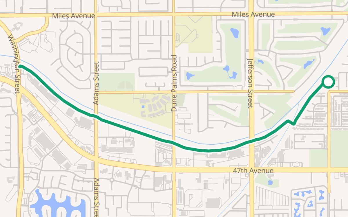 Shields Park to Washington StreetOn CV Link4.7 mi · ~25 min · out and back · 100% off busy roads · ↑ 43 ftWith kids
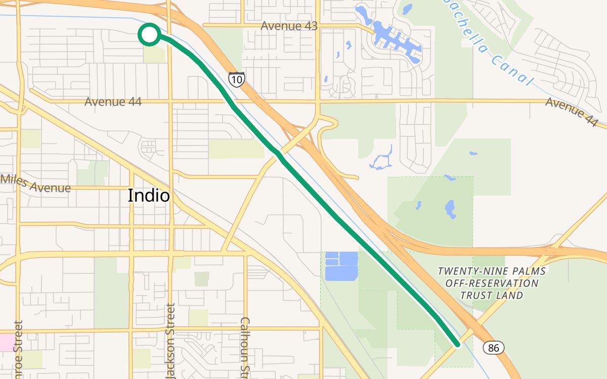 North Jackson Park to Dillon RoadOn CV Link5.8 mi · ~32 min · out and back · 100% off busy roads · ↑ 46 ftEasy rides